
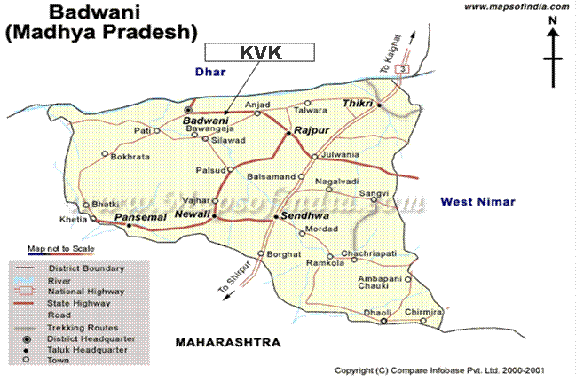
KVK Barwani- An Overview - District Profile
District Barwani was formed on 25th May 1998. It was carved out of West-Nimar, Khargone district. Barwani is situated on the south-west side of Madhya Pradesh as well as holy river Narmada is its northern border. District is surrounded by Satpuda (in South) and Vindhyachal (in North) forest ranges.
The name Badwani originated from the forests of Bad which had surrounded the city in old times. Wani is the old word for the Garden. and hence city got its name Badwani which means Garden of Bads. Barwani is still pronounced as Badwani but it spells Barwani.
KVK Barwani History
Town Badwani was the capital of old Badwani State before 1948. This small State was spared by British, Mughals and Marathas because of its rocky terrain and less productive soil. The Rana dynasty ruled the state throught the history. The history of this dynasty goes back to 13th century.Town Barwani was also know as Badnagar and Siddha Nagar . The place is also famous for Chool Giri , Jain pilgrimage centre of Bawangaja.
Barwani has a Historic Symbol which is known as TIR-GOLA. It is located at Khandwa-Baroda Road, in front of Sagar Vilas Palace and was built in the memory of late son of Raja Ranjit Singh.Before Independence Barwani was known as 'The Paris of Nimar'
Staff position:
| S.No. | Photo | Name of the incumbent | Designation | Academic Qualification | Field of Specialization | |
| 1 | 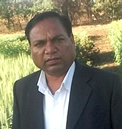 |
Dr. S.K. Badodiya | Senior Scientist & Head | Ph.D. | Agriculture Extension | Cell No. 9425678634 |
| 2 |  |
Dr. Dinesh Kumar Jain | Scientist | Ph.D. | Horticulture | Cell No. 9425511228 |
| 3 |  |
Dr. D.K. Tiwari; | Progrramme Astt. (Agronomy) | Ph.D. | Agronomy | Cell No. 9407079161 |
| 4 | 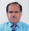 |
Dr. S.P. Tripathi | Scientist | Ph.D | Home Science | Cell No. 9893835704 |
| 5 |  |
Mr. U.S. Awasya | Progrramme Astt. (Computer) | MCA | Computer Application | Cell No. 9893850456 |
| 6 |  |
Mr. R. Bara | Account Officer | M.A. | Accounting work | Cell No. 9516691140 |
| 7 |  |
Nand Kishor Parte | Driver | 8th | Driving | Cell No. 9329373853 |
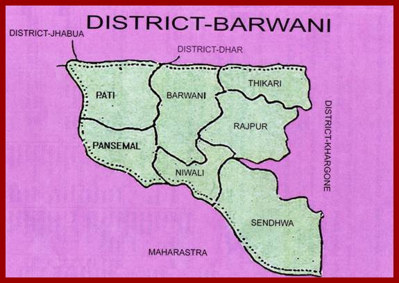
District Barwani
at a Glance
1.
Agro-climatic Zone - XI. Nimar Valley (Cotton-Jowar Crop Zone)
2.
Latitude - 21º 37' to 27 º 22' North
3.
Longitude - 74º
37' to 75º 37' East
4.
Altitude - 300 m from MSL
5.
Climate - Dry climate (hottest belt of the
country)
6.
Average rainfall - 773
mm
7.
Temperature - Maximum
43º C to 47º C
Minimum
8º C to 25º C
8.
Soil Type - a.
Clay loam (Black soil)
b.
Clay loam to clay (Alluvial)
c.
Sandy loam to clay loam (Alluvial)
d.
Sandy clay loam to clay (Hilly soil)
9.
Representing soil type - Medium
black soil
10.
Geographical area - 370810
ha
11.
Total Population - 10,81,039
12.
No. of Tehsils - 8 (Barwani,
Anjad, Thikari, Rajpur, Pansemal, Niwali, Sendhwa, Balwadi)
13.
No. of Blocks - 7
(Barwani, Pati, Thikari, Rajpur, Pansemal, Niwali, Sendhwa)
14.
Population density - 190/sq km
15.
Literacy percentage - 41.35%
16.
Adjoining district - Dhar, Jhabua
in North, Kharone in East, Maharastra
State in West
17.
Rural population - 85.35%
18.
SC/ST population - 64.83%
(SC 54.7%, ST 10.13%)
19.
Total cropped area (ha) - 161163
20.
Sole cropped area (ha) - 46896.13
21.
Double cropped area (ha) - 40654.9
22.
Irrigated area (ha) - 15836 (31% of total cropped area)
23.
Forest (ha) - 24077
24.
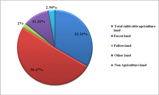
Cultivated area - 33.33%
25.
Forest area - 50.47%
26.
Barren uncultivated - 7.07%
27.
Permanent pasture land - 4.72%
28.
Cultivable waste land - 1.51%
29.
Non Agriculture land - 2.90%
30.
Agriculture workers - 85.35%
31.
Unemployed period - 4-6
months in off season
32.
Major enterprises - Agriculture,
Horticulture, Animal husbandry, Poultry
and Forestry
33.
Land use pattern of the district -
a.
Total cultivable agriculture land - 33.33%
b.
Forest land - 5.47%
c.
Fallow land - 2%
d.
Other land - 3%
34.
Major irrigation source - 85% irrigation by wells, tube wells
& narmada pipe lines
35.
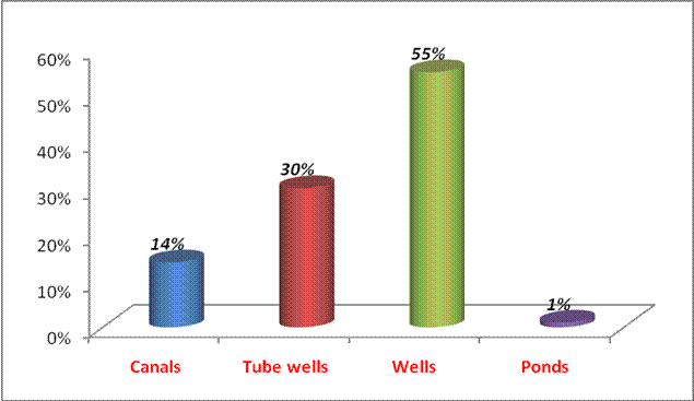
Irrigation source -
a.
Canals - 14%
b.
Tube wells - 30%
c. Wells - 55%
d. Ponds - 1%
36.
Land
holding pattern -
a. Large (>10 ha) - 6%
b. Medium (4-10 ha) - 24%
c. Semi Medium (2-4 ha) - 27%
d.
Small (1-2 ha) - 26%
e.
Marginal (<1 ha) - 17%
37.
Livestock position -
a.
Cows - 55%
b.
Buffaloes - 17%
c.
Goat & Sheep - 28%
d.
Total poultry - 357172
38.
Major crops - Cotton, Soybean, Jowar, Maize, Bajra, Arhar, Moong, Urd, Groundnut and Chilli in Kharif and Wheat
and Gram in Rabi
Block wise basic information
|
S.No |
Parameters |
Name of
Blocks |
||||||
|
|
Badwani |
Pati |
Thikri |
Rajpur |
Sendhwa |
Niwali |
Pansemel |
|
|
1 |
Soil Type |
Medium to
light black |
Medium to
black light |
Light
sandy loam to medium black |
Light
sandy loam to medium black |
Medium
sandy loam to black |
Sandy loam
to light black |
Medium to
light black |
|
2 |
Rainfall |
650-720 |
660-735 |
640-710 |
670-730 |
650-725 |
650-720 |
650-720 |
|
3 |
Total Area, ha |
45782 |
47032 |
56575 |
75572 |
81706 |
35239 |
29424 |
|
4 |
Cultivated area, ha |
29408 |
24586 |
34594 |
45867 |
54785 |
23733 |
24395 |
|
5 |
Irrigated Area, ha |
121165 |
4537 |
17215 |
18139 |
11496 |
6155 |
14879 |
|
6 |
Fellow area, ha |
1221 |
1360 |
1411 |
2979 |
1267 |
1026 |
4350 |
|
7 |
Cropping intensity |
119 |
110 |
115 |
120 |
120 |
115 |
120 |
Mandate of KVK:
|
MANDATES |
|
Technology assessment, refinement and
demonstration of technology / products |
THRUST AREAS
|
KVK Name |
THRUST |
|
Badwani |
Integrated
Crop Management |
|
Badwani |
Integrated
Disease & Pest Management |
|
Badwani |
Income
generation activities for empowerment of rural youth |
|
Badwani |
Drudgery
reduction for farm women |
PROBLEM IDENTIFIED
|
KVK Name |
Problem identified |
Methods of problem
identification |
|
Badwani |
Intensive and continuous cotton production resulted increasing use of fertilizer & low
productivity. |
PRA and Farmers Meetings |
|
Badwani |
Area and productivity of cereal and oilseed crops,
particularly soybean is towards declining trend. |
PRA and Farmers Meetings |
|
Badwani |
Indiscriminate and non judicious use of pesticides
specially in chilli for
controlling the leaf curl diseases. |
PRA and Farmers Meetings |
|
Badwani |
High level of drudgery during
agricultural operation by farm women |
PRA and Farmers Meetings |
Details of Instructional farm
|
Total area of KVK |
area of farm |
area under cultivation |
area under adm.bulding |
|
20.57 |
15.00 |
15.00 |
2.5 |
Outreach of KVK
a.
Map indicating following information’s through
separate symbol
·
![]() Adopted villages
Adopted villages
·
![]() OFT &FLD
OFT &FLD
·
![]() Trainings
Trainings
·
KMA
· ;
![]() Others if any
Others if any
![]()
![]()
![]()
![]()
![]()
![]()
![]()
![]()
![]()
![]()
![]()
![]()
![]()
![]()
![]()
(b) Coverage of Area
|
S.No |
Block
|
Villages
|
Percent converge (out of total villages) |
|
1 |
Badwani |
Kasrawat, Kalibedi,
Pichodi, Kathora, Palya, Balkuwa, Tallon, Pipari, Kundiya, BhilKheda, Nanhi Badwani, Rahgun, Sanjwani, Borlai, Dhanora, Kari, Bagud. Piplad, Lonsara, Silawad, Medimata, Utawad, Badwani |
|
|
2 |
Thikari |
Anjad, Fatyapur,
Barla, Surana, Haribad, Mandwada, Bawadia, Kuwa, Dawana, Kerwa, Keshawpura, Mohipura, Datwada |
|
|
3 |
Rajpur |
Chhotikhargone, Singun,
Mandil, Semalkhodra, Nandgaon, Pulsud, Rajpur |
|
|
4 |
Pansemal |
Pansemal |
|
|
5 |
Sendhwa |
Balwadi, Sendhwa |
|
|
6 |
Niwali |
Niwali |
|
|
7 |
Pati |
Pati, Bograta |
|
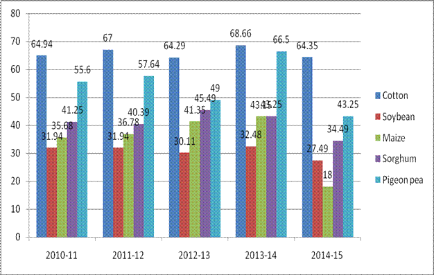
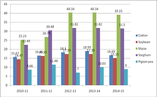
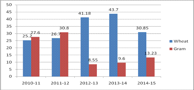
Productivity (q/ha) of Major Agriculture Crops Pattern of the district(B) Demographical information of district:
B.Irrigation source:
Area of Major Agriculture crops (Kharif)
Area of Major Agriculture crops (Rabi)
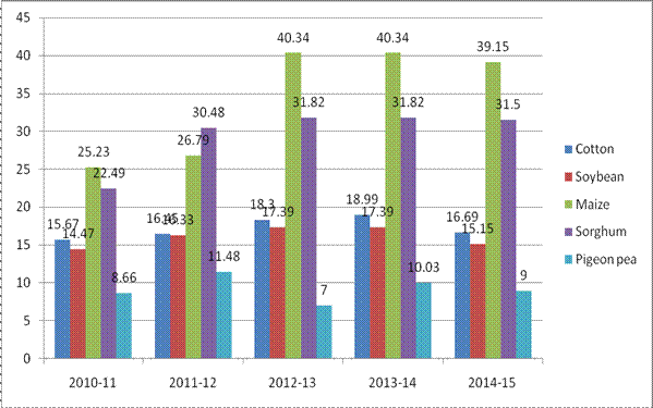
Productivity (q/ha) of Major agriculture crops (Kharif)
Productivity (q/ha) of Major agriculture crops (Rabi)
Area of Major Horticulture crops
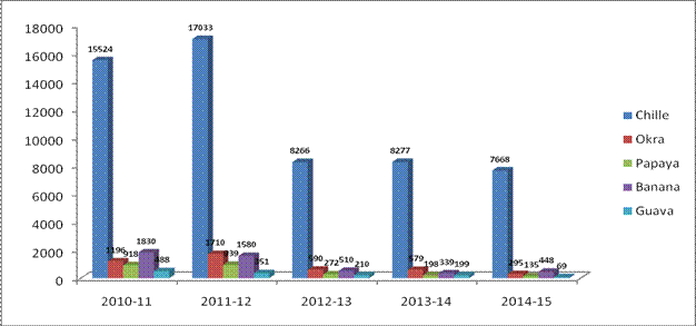
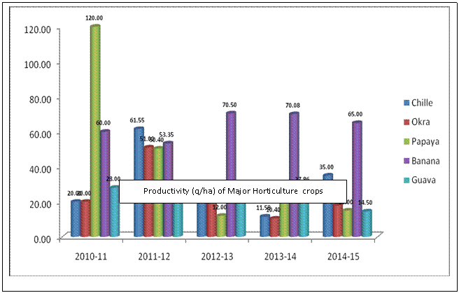
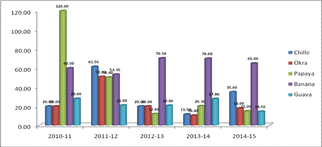
Productivity (q/ha) of Major Horticulture crops
Map of Soil type
Nimar valley Zone
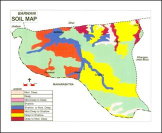
(Source
: NBSS&LUP, Amravati Road, Nagpur)
activities
Badwani(M.P.) - INDIA
Tel.: +91-07290-226330
Fax: +91-07290-226330
Important Links
Results published in the KVK Badwani website shall serve the purpose of only first hand information to the Farmers & Others. However the same indicated in Tabulation Sheet with KVK Manin Website with seal & signature by competent authority should be considered genuine for all purpose.
Last Updated on 04/06/2019 © All Right Reserved. KVK, Badwani, Madhya Pradesh, INDIA
